Tuesday, March 31, 2009
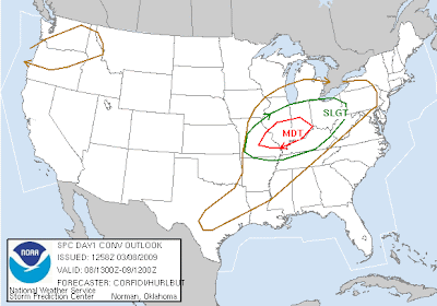
Slight Risk of Strong to Severe Storms Thursday
*The Nashville NWS office made a correction on the Murfressboro tornado. They rated it EF-0, but it actually was suppose to be rated EF-1. So they have made the correction and all three Middle TN tornadoes on Saturday were EF-1's.
*Our very own Matt Brawner went storm chasing Saturday in the Gallatin area where he caught some great images. I will post those images this afternoon once I get home from school.
Monday, March 30, 2009
Murfressboro and Huntland Tornado Ratings
A PRELIMINARY STORM SURVEY OF THE DAMAGE INCURRED ACROSS FRANKLIN COUNTY TENNESSEE HAS BEEN COMPLETED BY NATIONAL WEATHER SERVICE.INITIAL FINDINGS ARE AS FOLLOWS:
* EVENT TYPE: TORNADO
* EVENT DATE: 03/28/09
* ESTIMATED PEAK WIND: 90 MPH
* PRELIMINARY RATING: EF-1
* PATH LENGTH: 1.5 MILES
* MAXIMUM PATH WIDTH: 60 YARDS
* SUMMARY: NUMEROUS TREES WERE SNAPPED WITH SEVERAL CEDAR TRUNKS UPROOTED ALONG A LINE NORTH OF HIGHWAY 64...BETWEEN HUNTLAND AND MAXWELL. IN ADDITION...SHINGLES AND ROOF PANELS WERE PEELED BACK TO A HOME AND A BARN ALONG STRATTON ROAD AND PLEASANT RIDGE ROAD NEAR BRANCHVILLE.
THESE FINDINGS ARE PRELIMINARY AND ARE SUBJECT TO ADJUSTMENT.PICTURES AND SUMMARY MATERIALS WILL BE MADE AVAILABLE ON OUR WEBPAGE AT WEATHER.GOV/HUNTSVILLE /ALL LOWER CASE/.SURVEYED BY: COYNE/NADLER
Murfressboro, TN Tornado Rated; EF-0
THE TORNADO IN MURFREESBORO TOUCHED DOWN NEAR SCOTT STREET AND CAUSED SOME DAMAGE TO BUSINESSES THERE...AND CONTINUED ACROSS BROAD STREET WHERE IT CAUSED SIGNIFICANT DAMAGE TO SHOPS IN THE JACKSON HEIGHTS MALL. THE TORNADO ALSO CAUSED MAJOR DAMAGE TO THE BOYS AND GIRLS CLUB LOCATED ON JONES BOULEVARD. NUMEROUS TREES AND MINOR STRUCTURAL DAMAGE WAS OBSERVED TO HOMES NORTH OF LOKEY AVENUE...AND THERE WAS SOME STRUCTURAL DAMAGE TO BUSINESSES ON MEMORIAL BOULEVARD NEAR CLARK BOULEVARD. THE TOTAL PATH LENGTH OF THE TORNADO WAS JUST OVER A MILE...AND THE WIDTH WAS ABOUT 50 YARDS.
Sunday, March 29, 2009
EF-1 Tornado Confirmed in Cheatham County
EF-1 TORNADO TOUCHDOWN CONFIRMED IN CHEATHAM COUNTY...
AN ASSESSMENT TEAM CONSISTING OF NWS PERSONNEL SURVEYED DAMAGE TODAY IN CENTRAL CHEATHAM COUNTY. THE TEAM DETERMINED THAT AN EF-1 TORNADO WITH MAXIMUM WINDS NEAR 100 MPH WAS RESPONSIBLE FOR THE DAMAGE.THE INITIAL TOUCHDOWN WAS ALONG STATE HIGHWAY 249, 2 MILES NORTHEAST OF ASHLAND CITY, AND CONTINUED FOR 5 MILES ALONG HIGHWAY 249 TO JUST NORTH OF MOUNT ZION. THE INITIAL DAMAGE PATH WAS 50 YARDS WIDE AND INCREASED TO AROUND 100 YARDS WIDE.NUMEROUS HARDWOOD TREES WERE EITHER SNAPPED OFF OR WERE COMPLETELY UPROOTED. 1 MODULAR HOME WAS DESTROYED AND 3 OTHER HOMES WERE SIGNIFICANTLY DAMAGED.
Storm Reports: Ashland City and Huntland Tornado?
I think the SPC made a good decision on issuing a Tornado Watch for our immediate region. The SPC criteria for a tornado watch to verify, you need at least 3 tornado reports that are confirmed. Well, on the chart above in the watch they issued for most of Middle TN and points southward and NW, there were 5 different tornado reports in all. So if these tornado reports are confirmed by the local NWS offices...the watch verified.
It was a very bust day for the local NWS offices. It started in Paducah's region with a Severe T'storm Warning from the first, of many, supercells to form. Then Nashville came in next with a Severe T'storm Warning for Benton and Stewart Counties. Not long after that, Paducah then issued the first Tornado Warning of the evening. It was back and forth for the Nashville and Paducah offices on issuing warnings, until those warnings pushed out of the Paducah region, then Louisville started to get in on the fun. Then as the supercells started pushing further eastward, they started to form a line in which case the tornadic production would be cut down. As that line started to form, the offices in Huntsville and Birmingham had there own supercells to deal with. Only one tornado report came out of AL and that was in the NE part of the state almost into GA.
So all in all there were a total of 6 regional offices that had to issue at least one tornado warning last night. (Paducah, Nashville, Louisville, Huntsville, Birmingham, and Peachtree City)
***If you have any storm pictures for yesterday evening. I'd love to see them and post them on here! All you have to do is send them to my e-mail at charlesloring_2010@hotmail.com and post your name, where you took this image at, and what you are seeing.***
Saturday, March 28, 2009
MSD: Tornado Watch Likely
Severe Update: 3/28/09
Here are some current conditions around Middle TN.
Nashville: 60ºF/56º DP
Clarksville: 57ºF/57º DP
Cookeville: 57ºF/55º DP
Columbia: 58ºF/57ºDP
Manchester: 59ºF/58ºDP
Severe Saturday?
...TN/OH VLYS... A SEPARATE AREA OF SVR POTENTIAL WILL LIKELY
DEVELOP ACROSS PORTIONS OF THE TN/OH VLYS DURING THE AFTN/EVE.
STRONGEST DCVA WILL TRANSLATE NEWD AWAY FROM THE RICH GULF MOISTURE
SOURCE FARTHER SE. BUT...LINGERING 50S SFC DEW POINTS ARCING BACK
ALONG THE CDFNT/SFC LOW INTO THE LWR OH VLY BENEATH STEEP
MID-TROPOSPHERIC LAPSE RATES WILL CONTRIBUTE TO MLCAPES OF A FEW
HUNDRED J PER KG. EXPECT THAT SCTD TSTMS WILL DEVELOP AND
SLOWLY INTENSIFY FROM PARTS OF WRN KY/MIDDLE TN AMIDST STRONG
VERTICAL SHEAR.A FEW LOW-TOPPED SUPERCELLS MAY EVOLVE AND
ADVANCE INTO PARTS OF SRN IND...SWRN OH AND KY/ERN TN DURING THE
EVENING. LARGE HAIL AND ISOLD DMGG WIND GUSTS WILL BE
POSSIBLE. TORNADOES CANNOT BE RULED OUT...ESPECIALLY WITH MORE
SUSTAINED STORMS AND CLOSE TO THE SFC LOW TRACK. SVR THREATS
WILL DIMINISH WITH NE EXTENT AND AFTER SUNSET.
Friday, March 27, 2009
Saturday Storm Update: Charles' Predictions
SCK: Threat will be limited due to warm front getting to this region, but that actually might increase the tornado chances due to the surface low passes that much closer giving us the strong winds aloft.
Storm arrival time: 10 am-2 pm
The strongest possible storm to impact this region would have these possibilities: Large hail (.75-1.25"), Damaging winds (65 mph), and a tornado.
Northern Middle TN: Threat will be much like SCK, but since the warm front will actually be over them...that will keep you in the warm sector long enough to have some better destabilization. But they might be close enough to the "triple-point zone" to see an isolated tornado or two also.
Storm arrival time: 10 am-3 pm
The strongest possible storm to impact this region would have these possibilities: Large hail (.75-1.5"), Damaging winds (65-70 mph), and a tornado.
Western Middle TN: Since storm arrival here will be earlier then most everyone else you guys won't have the "daytime heating" to help destabilize the atmosphere more then say areas in eastern Middle TN. With that said, I do believe the potential is there for an isolated tornado due the surface low being as close as it is.
Storm arrival time: 8 am-Noon
The strongest possible storm to impact this region would have these possibilities: Large Hail (.75"), Damaging winds (60 mph), and a tornado.
Eastern Middle TN: This area will have an increased risk then say western, northern, and SCK due to the time it will be able to destabilize. The tornado risk looks low in this region, but since the unstable air mass will be in place, it is still a risk. I do see the southern edge of this part being in a MDT risk come Saturday morning...at least.
Storm time arrival: Noon-5 pm
The strongest possible storm to impact this region would have these possibilities: Large hail (1"-1.5"), Damaging winds (65-70 mph), and a tornado.
Southern Middle TN: This area has the biggest chance at seeing severe weather. This is due to the higher instability values being in this region, and since they will be in the warm sector longer. I do see this area being upgraded to MDT risk by the SPC in there next outlook for this region.
Storm time arrival: 10 am-4 pm
The strongest possible storm to impact this region would have these possibilities: Large hail (1"-1.5"), Damaging winds (70 mph), and a tornado or two.
Friday Night Not So Bad...Can't Say Same For Saturday
Many of you may be wondering about today and tonight. Well for today, we will have some scatter showers/t'storms around today, but severe weather isn't expected. The same scenario is forecasted, but the arrival of it has slowed down and that is why we think mid-day Saturday is when we will most likely see the strong to severe storms.
I will have an update later on today and will try to pin-point actually what areas may see what severe weather, and how much rain we may see too.
Thursday, March 26, 2009
Tomorrow and Saturday's Severe Risk
Wednesday, March 25, 2009
Rain Today; Severe Storms Friday and Saturday
Now here is the big boy I have been telling you guys about. The SPC has issued a Slight Risk for areas in LA, MS, AR, AL, TN, and KY. That is a large area and it looks like this potential for severe storms is growing in likelihood. While you can see that most of the 30% area is too are west, many people in Middle TN area in the 15% hatched area while SCK we are in just the 15% risk area.
The difference between hatched and unhatched outlooks is simply this...if it's is hatched, there is the possibility of damage (either hail, damaging winds, or tornadoes) within a 25 mile radius from your location. And if it is unhatched, then there is a risk for storms in that area as a whole.
Monday, March 23, 2009
Afternoon/Nighttime Forecast; Friday Severe Event
Nashville: Partly Cloudy / 66 degrees / Winds are South at 5 mph
Smyrna: Partly Cloudy / 72 degrees / Winds are Calm
Clarksville: Partly Cloudy / 70 degrees / Winds SSE at 5 mph
Here's how your week looks to shape up
Tuesday, Mostly Cloudy, High near 73 degrees
Wednesday, Thunderstorms Likely, High near 66 degrees, Chance of Rain 90%
Thursday, Mostly Cloudy, High near 66 degrees, Chance of Precipitation 30%
Friday***, Thunderstorms, High near 71, Chance of Rain 50%
Friday has asterisks because it looks as though we might be seeing some spring-time storms roll in to the Ohio Vallay. Current NAM and GFS Computer Modles indicate a very potent atmosphere for severe weather to form. This is along the Gulf Coast States and extends northward into the TN and OH Vallaey regions...right now my main concern is the fact taht with each new run, the models continue to indicate a VERY moist and unstable environment establishing itself in the areas mentioned. . . . . .for right now GFS illustrates us ua having 65+ degree dewpoints, and an Impressive CAPE value near 1200, 2300 j/Kg. Please remember it is still 90+ hours until then, but this looks like a very serious situation unfolding and I hope you watch it carefully.
Have a good night, and I would like to give a BIG shoutout to Meagan Wade. . she says she enjoys our site and we appreciate that.
Friday Severe Chance
Sunday, March 22, 2009
Evening Forecast; Severe Chances on the Horizon
Here's your current conditions:
Nashville: Partly Cloudy / 64 degrees / Winds are out of the South at 5 mph
Smyrna: Partly Cloudy / 66 degrees / Winds are Calm
Clarksville: Mostly Clear / 63 degrees / Winds are ENE at 6 mph
Here's the quick forecast for the week ahead.
Monday: Partly Cloudy, High near 71
Tuesday: Mostly Cloudy, High near 73
Wednesday: Thunderstorms Likely, High near 65, Chance of Precipitation 60%
Thursday: Partly Cloudy, High near 68
Wednesday might have severe weather in store for our area. At the current time, The Storm Prediction Center has a "Slight" Risk area issued for areas, mainly in Arkansas, Texas, Louisiana, and Mississippi. Current thinking is that a deep surface low pressure system that should move through Wisconsin into Lake Superior area on Wednesday, a trailing cold front should sweep across the area. A marine warm front will also slip up into the region providing a space for warm, moist air to establish before the cold front sweeps through. We think a linear convective band will be ongoing at 6Z on Wednesday and continue through into the slight risk area. The warm sector should provide a good area for rapid storm development and intensification. Now, all this activity will stay to our south, but we cannot rule out an isolated damagiung wind storm, or even a small hail producer.
**WEATHER NERDS!!! If I were you i'd watch the plains tomorrow, the SPC has a "Moderate Risk" out for a small portion of the area** http://www.spc.noaa.gov/
Have a good night and stay safe!
Midday Forecast
Current Conditions at Nashville International Airport
Sunny
Temperature: 66 degrees
Humidity is at 32%
Winds are SW at 7 mph
Expect this weather to stay around, at least for the rest of today. It looks like we are running a VERY SLIM chance of seeing a sprinkle tomorrow, then Tuesday on into Wednesday we see our chances of precipitation increase dramatically as we will have a front sweep through the mid-south, that's giving us our rain chances and dropping our temperatures about 5 degrees for your Wednesday and Thursday.
Have a good rest of today, and check in tonight for the severe weather chances we might get on Wednesday!
Saturday, March 21, 2009
Nice Start To First Spring Weekend; Severe Storms In Our Future?
On radar, we have some virga, precipitation not reaching the ground, showing up on radar at this time. I don't expect much in the way of rain for anyone til next week when we do issue a shower/storm chance.
Now onto what I am really watching with urgency...the Friday storm potential. The models, and the SPC has this mentioned, have been showing a system swing through our area during this timeframe and with it we could see some severe weather. Right now it looks like most of the action will stay to the south of us, but with this possible event 6-7 days away...things may change. Fred, Matt, and I will continue to discuss this event as it unfolds. And what I may start doing is get all three of ours thoughts on the severe systems that impact us, and post them and let you see how much we agree or disagree with one another.
Friday, March 20, 2009
Cooler, but Sunnier Day; Outlook for Stormy Plains States
We won't see a rain chance til the middle to late next week, so your weekend should go uninterrupted as far as weather goes. I'm going to be watching the models the next couple of days as it it looks like some severe weather is likely for some of our friends in the Plains states around OK, KS, and TX. It is still too early to tell what forms we might see from this setup. It could be a big squall line type deal for them, or it could be discrete, individual supercell type setup that will lead to a bigger tornado probability. All I have to say is that the meteorologist at the SPC have their hands full with this system.
Wednesday, March 18, 2009
Showery/T'showery Weather Tonight and Early Tomorrow
For most of your night tonight, you can expect mostly rain-free skies with some cloud cover increasing from the west/northwest with our next cold front and rain threat. Some heavy rain with thunder and lightning could occur, but severe weather will not be a problem with this system.
Most of this rain should be out of the mid-state region by early tomorrow afternoon, so your Thursday night plans should go without the need of a rain jacket or an umbrella. But with like I mentioned, what is bringing in this rain is a cold front that will make our temps. retreat a tad. We will still be relatively warm (forecasting 62ºF in Nashville tomorrow), but areas east of Nashville may not make it out of the 50's tomorrow.
Monday, March 16, 2009
So Long Seattle Weather; Hello Sunshine!
Saturday, March 14, 2009
Rainy Saturday; Cloudy Sunday
We do expect most of this rain to push east of the Music City region by mid-afternoon and leave the region completely by early Sunday morning. The clouds will still be around all day tomorrow, but the high's will be on the increase yet again.
Thursday, March 12, 2009
ISW Warnings Up for Some Rim and Plateau Areas; WWA For Rest
* .25" to 1"+ of ice could be seen in these regions tonight. Those amounts will snap trees and power lines, so we will watch or any reports out of those areas tonight and early tomorrow morning.
For almost the rest of Middle TN and SCK, a WWA (Winter Weather Advisory) has been issued until midnight. You can find which counties are in these advisories in this link here http://forecast.weather.gov/wwamap/wwatxtget.php?cwa=ohx&wwa=winter weather advisory
* For people south of I-40...some small ice accumulation is possible as well as some sleet accumulation up to 1/2".
* For people north and northwest of Nashville...up to 1" of snow and sleet can be expected with some localized higher amounts. Small ice accumulations are possible as well (Have some here at my house in Macon County).
I will keep you up to date on any changes that could come with this winter weather system unfolding.
Wednesday, March 11, 2009
Call Map...or lack their of! 3/11-3/12 Event
Stewart, Robertson, Humphreys, Dickson, Houston, Benton, and Montgomery Counties: 1-2" of snow and sleet accumulation
Sumner, Perry, Hickman, Cheatham, Williamson, Davidson, Wilson, Trousdale, Macon, Clay, Smith, and Jackson Counties: 1" of snow and sleet accumulation, <.10" of ice possible as well.
Elsewhere Counties: No sleet/snow/or ice accumulation. Could have some sleet mixing in with rain however.
All South Central KY Counties: 1-1.5" of snow accumulation. .10"-.20" of ice accumulation possible.
Winter Storm Approaching...Northern Middle TN This Go Around!
Tuesday, March 10, 2009
Record Setting Day?; Few Storms Tonight
With this cold front, many people are asking if we will see strong storms. Yes strong storms...are possible, but I'm not expecting too much in the way of severe weather. Just like the event we had Sunday where most of the dynamics and severe weather went well north of us, this will be much the same. We will watch the radar and keep you up to date, but this will not be a widespread event by any means. Only people to the N and NW of Nashville should really watch this system, but what will affect all of us is the wet and rainy weather! Which would be a welcome site to many because my yard has still not completely recovered from the drought of 06'. Which that is quite a severe weather episode of its own...
Monday, March 9, 2009
Recording Setting Warm? Return To Cold Ahead
But...like always, what goes up, must come down and that is exactly what will happen. Late Tuesday into early Wednesday morning we will have a strong cold front swing through the region and with it could be severe weather. But what will be with it for sure is cooler temps.(High's in the 50's).
Sunday, March 8, 2009
Middle TN Warnings
This storm has the chance at damaging winds. Weak rotation has been registered in this cell too.---EXPIRED
Severe T'storm Warnings in Effect For Portions of SCK
Barren and Warren County cell is registering a 1.50" hail indicator. And could contain 60 mph winds.---EXPIRED
Logan County storm has the potential to produce 60 mph winds.---EXPIRED
Adair and Metcalfe Counties cell has the chance at nickel size hail and 60 mph winds.---EXPIRED
UPDATE: Moderate Risk For Storm Out for IL/IN; Slight Risk Moved Southward
Slight Risk For Severe Storms, NW Middle TN; Strong Storms Elsewhere
This morning, a squall line type system is being set up over in Western MO where a Tornado Watch is in effect for them. I expect that line to continue its march eastward today and impact us by the later afternoon going on into the evening hours. Even though most of Middle TN is excluded from the risk area...we still need to watch this line closely as we could very well see some strong to severe storms from this line.
Friday, March 6, 2009
70's! Need I Say More?
Thursday, March 5, 2009
Nice, Windy Day Ahead; 70's For Your Friday and/or Saturday?
With all that being said, I do expect us to enter a wet and stormy period come early next week. The models have been hinting at it for some time and I do expect us to see some stormy and soggy weather. Could be soggy enough that we could be dealing with some flooding issues. We will continue to watch that and see how it will affect the South Central KY and Middle TN regions...
Tuesday, March 3, 2009
Welcome Back To Spring...But Will It Last?
The models have been hooking on to a cold spell for a good chunk of March from the mid portion of the month til almost the end of the month. But for March, I'm really not buying that long of a cold period. Maybe we will get 2-3 days of some colder weather, but no real long period like the models are saying.
What would trigger this type of weather pattern would be a strong storm system to impact us and that would help usher in the colder, artic air. The models have backed a bit off the severe numbers, but the numbers given yesterday where a good bit alarming and I'm not at all surprised to see it put on the brakes a bit.
Monday, March 2, 2009
Cooler Night; Warming Trend Coming Soon!
"No Man's Land" Outlook: The models have been in a favorable trend for a severe event come next week. The timing and intensity is still way too far out to even think about forecasting that, but we will continue to keep a close watch on it as it looks to be the next big weather maker.
Nashville: mid to upper 10's (17ºF)
Clarksville: mid 10's (14ºF)
Cookeville: low to mid 10's (13ºF)
Columbia: mid 10's (15ºF)
Manchester: low to mid 10's (13ºF)
Sunday, March 1, 2009
Middle TN SnowStorm of 09'!..."Zilch of 09" For Others
I was gone to Gatlinburg this weekend and missed the snow their too (Left right as it was starting)! And when I got home I saw our good snow amount...0.0". As disappointed as I was on our non-event, I was happy to see some of the snowfall totals out of Middle TN. Some areas even in western TN got upwards of 16"+ with higher snow drifts. That amount is crippling to the Northeast, so you can fathom how difficult it was for us here in the Volunteer state to handle it. This morning, I head that I-40 from Jackson to Memphis was shutdown from last night all the way to this morning due to the wreaks caused by the great snows and people where stranded and waiting for help.
Looking to the future, I don't see another event like this (won't for a some good time), but what I do see is great weather conditions for your week with some area showers/ t'showers moving into the region by late this week into next weekend.