Thursday, April 30, 2009

Scattered T'showers Again; Severe Threat Increasing

Good morning everyone, I have a lot to cover with you weather wise as we have a lot to deal with this coming weekend. We will see the scatter showers/t'showers today like we saw yesterday and the favored areas this go around with be the areas to the west and NW of Nashville.This is the SPC's outlook for tomorrow. We look to have a line of storms move through our region which could bring with it some damaging winds.
This is the outlook for Saturday and you can see that they also have all of Middle TN and SCK in the Slight risk for this day too. We look to see some "pop-up" severe storms on this day so we could have to deal with some large hail with this batch.
And if those two days aren't enough...we see on the Day 4 outlook that we have yet another wave of severe weather that could impact us.
OHX is telling all spotters that we may need activation from Friday night through Sunday. This could be my first few events where I go out as a spotter and report back to the NWS!
*Also the models are showing that places North of Nashville could see rainfall totals in the 3-4+" range. Those totals are going to cause some flooding and we will keep a close watch on this flooding potential as well.


Wednesday, April 29, 2009

Severe Storms Possible Friday; Scattered T'storms Today

The SPC has outlined this outlook for the day of Friday, May 1st. You can see that the areas in Middle TN sit right on the fringe of the Slight risk zone. The areas that are in this zone are places to the N and NW of Nashville as well as areas in SCK. The biggest threat with this system will be large hail and damaging winds. But we will have to watch it closely as May is one of our big severe weather months.

Today, we will see some widely scattered showers/t'showers today with a few embedded t'storms. We aren't expecting any severe weather today, but in the strongest of storms...you could see some gusty winds and small hail. This activity should begin to "pop" later on this morning into the afternoon hours.

UPDATE: OHX has posted this in their morning AFD. These are a few convective numbers for today's event.

MODIFIED GFS SOUNDING FOR BNA FOR A MAX TEMP OF 77 TODAY SHOWS THE FOLLOWING CONVECTIVE STATISTICS: LI -4, CAPE 1092 J/KG, TOTAL TOTALS 47, PWA 1.32 INCHES

Tuesday, April 28, 2009

"Pop-Up" Storms Today...Mainly West of I-65

We will see some storms fire later this afternoon in the heat of the day, we are not expecting an organized event, but we can't completely rule out one or two severe storms with hail and damaging wind gusts. We will keep these rain/storm chances in the picture through Saturday, at least. With all this rain and cloud cover around, the 80's will take a backseat ride for a little while and let the 70's take back over. But with all this said, temps. in the mid 70's are still above average for this time of year.

Nashville: upper 70's; 50% chance
Clarksville: upper 70's; 70% chance
Cookeville: upper 70's to low 80's; 30% chance
Columbia: upper 70's; 50% chance
Manchester: upper 70's to low 80's; 30% chance

Sunday, April 26, 2009

Monday's Forecast

Good evening to all! It was a very pleasent day here in Middle Tennessee. The sun was out in force, with only a few clouds around to provide some shade. Area highs today were in the lower-to-middle 80's. Here are some local conditions:
Clarksville: Clear, 77 degrees, Winds S at 8 m.p.h.
Smyrna: Clear, 79 degrees, Winds SSE at 7 m.p.h.
Nashville: Clear, 75 degrees, Winds S at 9 m.p.h.

Tomorrow's Forecast:
Partly Cloudy
High near 84 Degrees
Low near 62 Degrees
Winds: 5-10 m.p.h.
Chance of Precipitation: 5%

3-Day Outlook
Tuesday: Mostly Cloudy, High near 77, Chance of Precipitation 40%
Wednesday: Thunderstorms, High near 76, Chance of Precipitation 50%
Thursday: Thunderstorms, Hear near 77, Chance of Precipitation 50%

A bit of weather news: The Plains States are getting smacked by severe weather tonight.! Follow the latest on this "High Risk Day" at http://www.spc.noaa.gov/

Beautiful Spring Days Continue! Plains Severe Weather "Outbreak"

Good Sunday morning everyone! I hope you guys got out and enjoyed the day yesterday like I did. I walked and ran up my street a couple of times and threw the old pigskin with a few of my friends who were here at my house watching the draft. Today will be indeed another day to do the same. I, hopefully, will be going to a concert today at the local park here in Lafayette where a couple of my friends are in a band and they will be playing a long with 4 other groups from around the region. It is going to be an awesome day and the weather couldn't be any better!

Now, on the flip side, it looks like our neighbors out in the western Plains region will be seeing a big severe day today. You guys should know by now that I don't like using the term "outbreak" unless it will be a pretty good event with many tornado reports and/or the atmosphere has the abililty to produce a very destructive tornado or two (EF-3+). Well...today is one of those days. We already have a Tornado Watch out for places in Central KS this morning and have already seen a couple of Severe T'storm Warnings to Tornado Warnings issued. I do see that action quiting down later on this morning and we will have to wait til later on during the day (after 2-3 pm) for the second wave to get going and surge its way across the TX/OK/and KS regions.

Saturday, April 25, 2009

80's! Warm, Dry Weather Here To Stay?

Good morning all, I want to first apologize for the lack of posts this week. I have a little bit of a personal problem that I need to get resolved and that has hampered my blog posting. It isn't worked out yet, but hopefully it will here soon.

Now, what a gorgeous past few days this has been for us here in Middle TN and SCK. We did have the few isolated showers/t'showers come through our regions Thursday, I believe, and that is about all in the way of things we have seen thus far weather wise this week. We will keep the 80º weather here for at least til the middle of next week when we do have a disturbance out to our west that will move through here and cause us to see some spring time pop-up storms from Wednesday onward. The only thing that will do as far as temps. go is drop them down to the mid 70's! Which that is still great weather! Hope everyone has a good day today...I will with the NFL Draft going on!

Wednesday, April 22, 2009

Nice Days Ahead; I Am Now SKYWARN Certified

As this ride of good weather continues, we will not see another drop of rain for at least 7 days! And also, we will see high's reach well into the 80's come Friday through Sunday! If that doesn't get you excited, I do not know what will.

Last night, I attended the NWS spotter class they were offering here in Lafayette. There were about 30 people in attendence and only 3 where of my age, which was surprising to me. I would like to go out and practice my spotting skills a bit...but it looks like Mother Nature is taking a little break from this region for a while. But I'm not complaining about that!

Tuesday, April 21, 2009

Great Weather Days Ahead; Storm Spotter Class Tonight

Good morning everyone! Today, we are going to see some very nice weather. We will see the morning sun give way to some afternoon clouds, but overall this will be the first day with no rain...with many more days like this coming. Our high's today will be much like yesterday's (66ºF in Nashville). But if you wait til this weekend, we could very well see 80's pop-up in places with sun skies! That sounds more like it too me!

Tonight, I will be attending my first storm spotter class. It will be at 6:30 here in Lafayette. I hope we have a huge crowd tonight as I would say many people in this town are more weather prepared then ever. That is why I am happy Tom Johnstone and the rest of the OHX staff, chose to do a class up here.

Sunday, April 19, 2009

Opps! Sorry about the text box below!

*There are also Severe T'storm Watches out to our west. We could very well see those watches issued further east and include us too.

Isolated Strong to Severe Storms Possible Today Across TN Valley

Many of us are waking up to a good sounding rain outside with not much thunder present at all. This morning rain should begin to decrease in coverage as we head into the late morning hours as a dry slot will begin to work its way into our region. With this occurrence, we will see more atmospheric destabilization and that is why the SPC has Middle TN and SCK in a Slight risk of storms today.

The main risks with the strongest of storms will be damaging winds and large hail, but an isolated tornado or two can't be completely ruled out either...but that threat is low at this point. When I get home from church at around noon, I will have a blog update if necessary.

Saturday, April 18, 2009

Sunday's Severe; Thunder Over Louisville

That's right guys, we have yet another severe risk for our region and this one looks to affect us Sunday afternoon and evening. We could see some storms move into our western most regions tonight, but they won't have the potential to reach severe criteria.

The strongest storms, for Sunday, will have the potential at damaging winds and large hail. The tornado threat is pretty low with this system as the shear doesn't look to be all that strong. Actually, this whole event looks pretty weak, but since their is an outlooked region...we still need to follow it closely.

* There will be another kind of loud booming going on in Louisville tonight. It's called "Thunder Over Louisville" and it is the largest fireworks display in the US annually and is also an event with one of the biggest air shows too. Over 650,000 people attend this event and I hope to one day as it sounds like a pretty cool event.

Just to tell you how many fireworks will be sent off...over 52 tons! And it will be in a 30 minute timeframe.

Ryan Hoke, who is one of my good friends from Louisville and wants to become an OCM too, has written about this event on his blog http://www.ryanweather.blogspot.com/ and you all should check it out!

Thursday, April 16, 2009

Finally...Some Sun! 70's Tomorrow!

After being stuck under the clouds all day yesterday, and some not getting out of the 40's, we should see those clouds break up today as that High pressure system moves eastward and takes those clouds with it. With the departure of these clouds, we should see our temps. rise into the mid to upper 60's (western sections of Middle TN could reach the 70ºF mark) with sunshine for all.

Tomorrow, many will see those thermometers reach the 70º mark by afternoon.

But, we do see a shower/t'shower chance come back into the region late Saturday into your Sunday. This round does not look to produce any severe weather, but remember that if you see lightning or hear thunder...move indoors.

Nashville: Clouds clearing; 67ºF
Clarksville: Sunny; 69ºF
Cookeville: Clouds clearing late; 64ºF
Columbia: Clouds clearing; 67ºF
Manchester: Clouds clearing; 66ºF

Wednesday, April 15, 2009

Tornado Fatality Numbers by States: Tennessee Ranks #1

I ran across this story while visiting nashvillewx.com and found these numbers to be scary and a problem that needs to be fixed. http://www.wkrn.com/global/story.asp?s=10183698

Monday, April 13, 2009

The SPC has a slight risk of severe storms all across Middle TN today, but the biggest threat will be large hail. As you can see, they have placed areas from Nashville northward in a 30% wind threat while the rest of Middle TN is in the 15% risk. Also, damaging winds is a threat as is a isolated tornado or two too with our temps. getting up to 70ºF and DP's well into the 50's. Now, if we do see more sunshine today then expected, then our risk will go up that much more. The best time for us to see these storms will be from late morning (noon) through the mid-afternoon hours in eastern sections (7-8 pm). Good thing is, after we get this system out of here...we should be dry for the rest of the week.

Sunday, April 12, 2009

A lot of Catching Up To Do! OHX Storm Surveys

Good day to all our blog readers. Even though I missed blogging Friday's event, I was keeping a close watch on it all day and was doing a lot of stormtracking. Of course, the Murfreesboro tornado was rated the highest (EF-3), but that is just an preliminary rating as it could very well be upgraded to EF-4 later on. Here's a list of other TN tornado ratings.

...EF1 TORNADO TOUCHDOWN CONFIRMED IN SUMNER COUNTY...

Location: 8 miles SW of Portland
Intensity: EF-1 (100 mph winds)
Damage: 3 FRAME HOMES AND A MOBILE HOME SUFFERED SIGNIFICANT ROOF DAMAGE ALONG CREEKMORE ROAD. NUMEROUS TREES WERE SNAPPED OR UPROOTED.

...NWS CONFIRMS EF-1 TORNADO DAMAGE IN BENTON COUNTY...

Location: 6-10.5 miles NE of Camden
Intensity: EF-1 (100 mph winds)
Damage: MUCH OF THE DAMAGE WAS ALONG AND NEAR GRAPEVINE AND HARMON DOCK ROADS. MANY HUNDREDS OF LARGE HARDWOOD TREES AND PINE TREES WERE SNAPPED OR UPROOTED ALONG THE DAMAGE PATH. TEN HOMES SUFFERED ROOF DAMAGE AND SEVERAL OUTBUILDINGS WERE DESTROYED.

...PRELIMINARY RESULTS FROM A SECOND TORNADO IN RUTHERFORD COUNTY...

Location: 8-10 miles SE of Murfressboro
Intensity: EF-1 (100 mph winds)
Damage: 4 HOMES WERE DAMAGED ALONG WITH A BARN...AND SEVERAL TREES WERE SNAPPED OR UPROOTED.

*I will have more on the first Murfressboro tornado once the report is done.

Friday, April 10, 2009

Severe Weather Possible Later This Afternoon

As Charles has mentioned the past couple of days....Tennessee could experience some severe weather. As of right now the Storm Prediction Center has much of the Mid-South including TN, KY NC, SC, MS, AL, and Georgia in a "Slight Risk" of Severe Weather. With that there is a secondary risk area...a higher "Moderate Risk" area. That includes Middle and Eastern Tennessee. The highest threat we are expecting is LARGE DAMAGING Hail. up to 2" in diameter. Damaging Winds are also likely. With our favorable shear and expected moist atmosphere later today.. Supercells with Tornadoes are possible as well.

Continue to monitor NOAA Weather Radio and Local Media Outlets for the Latest Severe Weather Information.

I will post periodically throughout the day as the situation unfolds.

Thursday, April 9, 2009

Severe Storms Likely Tomorrow Afternoon and Evening

The SPC has placed many areas of Middle TN under the 30% hatched region, excluding the western Middle TN counties. The SKEW-T soundings have been down right scary bringing in huge instability values for us and with all that said, Friday is going to have to be a weather alert day. I except us to get put into a Watch (most likely Tornado) sometime tomorrow around noon. The action should begin to fire after the 1 pm time frame and even some models have it out of Nashville by 7-8 pm. So we may have a 5-6 hour window where discrete iso-cells could form and a few of those could reach supercell status where all thre severe elements could be possible. I will say that the highest threat looks to be damaging hail with some reaching close to 2" in size.

I won't be here til Sunday afternoon, but I will ask Matt or Fred if they could give our blog readers the latest on this threat.

Wednesday, April 8, 2009

Same Pattern...Same Severe Chances

Here we go again! Yet another severe chance looks to impact our region on Friday and this one is "more potent" then any we have seen thus far, in my opinion. The SPC is thinking all three forms of severe weather could occur Friday across our area...hail, damaging winds, and tornadoes.

I will say that since this event is still two days away, the models can change, but each hour we get closer to the event the less time it has time to change its course. I won't be here from Thursday night into Sunday morning (going to a church youth group convention in Nashville). But I will try to get either Fred or Matt to blog post in my place, since we are looking at the potential for severe storms.

Monday, April 6, 2009

Winter Weather Advisory Issued for Northern Highland Rim and Plateau Counties

The NWS office out of Nashville, has issued a WWA for the following counties: MACON-CLAY-PICKETT-TROUSDALE-SMITH-JACKSON-PUTNAM-OVERTON-FENTRESS-DEKALB-WHITE-CUMBERLAND

1-2" snow accumulation could be very possible in these areas once you arise tomorrow morning. Some slick spots on the area roads could occur as well, especially in the overnight and early morning hours. If you are adjacent to one of the counties mentioned in the WWA, you may see accumulation up to an inch. But the higher amounts are going to be on the Plateau regions or where the WWA is issued for. But we have seen time and time again that even when they issue these advisories...we could very well not see anything anywhere. So I will be here giving you the latest information on this wintry situation.

Sunday, April 5, 2009

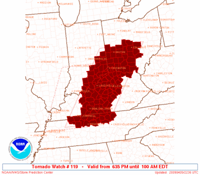
Tornado Watch #119: All of Middle TN and Portions of South Central KY

***All of Middle TN is now included in this watch.***

Tornado Watch #117: Portions of Northern Middle TN and South Central KY

SPC is thinking that storms will begin to fire out ahead of the front, and some of them could gain supercell structure and potential. There are already some warnings out in MO and far western TN. So we will watch this closely and a new watch may very well be added for the counties not included in this one, especially the counties on the TN/KY border...

Slight Risk Today; Damaging Winds and Large Hail Main Risks

We are expecting some "iso-cells" to pop-up put ahead of the cold front later on today and into the evening hours. It is possible that some of these iso-cells could form into low-topped supercells and have the potential for damaging wind gusts, large hail, and even an outside chance of an isolated tornado. The time frame we are expecting this action is from 4 pm in western Middle TN through 9 pm in far eastern Middle TN. The action should begin to die down after the sun sets and we lose a lot of our surface heating...

Saturday, April 4, 2009

Another Severe Chance; Light Snow Chance Too?

The SPC is thinking there will be two areas of concern for severe weather Sunday. The first is for the Deep South areas, while the other area is up into the Northern Middle TN areas and SCK. They are forecasting a broken line of low-topped supercells will make there eastward march through this region and will have the potential at large hail, damaging wind gusts, as well as an isolated, brief tornado or two in the stronger storms.

Behind this cold front will be some very cold air. I'm thinking we could have two nights of below freezing temps. and on the first night...some snow may be in the air across areas of the Highland Rim and Cumberland Plateau. I'm not expecting accumulating snow by any means, just enough to give you that last winter feel. So with all this said, if you have plants you have already planted...make sure you cover them up on both Monday night and Tuesday night.

Friday, April 3, 2009

EF-1 Tornado Confirmed in Nashville

Here's the link to the findings, pictures and damage map is shown...http://www.srh.noaa.gov/ohx/surveys/ss040209_davidson.php

Rainfall Totals From Thursday and Thursday Night; Storm Survey Today

These are the radar estimates of rainfall totals and here's a few rain totals.

Cookeville: 1"
Glasgow, KY: 2.5"-3"
Nashville: 2"-2.5"
Ashland City: 1"
Franklin, TN: 3"-3.5"
Dover: 1.5"-2"
Lafayette: 2"-2.5"

All this rain is now out of our region, and we should be rain or storm free til at least Sunday where another cold front will push through here. Severe weather looks low at this point for us, but the models have had the low pressure center up around Southern IL and if that comes to happen...we will be in the heart of severe weather. So we will continue to watch that too. But we will also get out and enjoy these next couple of sunny days!

*Nashville's NWS team will conduct a storm survey of the damage done in the Murfressboro Rd. areas in Donelson some time today. We will find exactly how strong this tornado might be. From looking at damage...I'm think at least EF-1 and could be rated a weak EF-2.

Thursday, April 2, 2009

Tornado Watch #112: All of Middle TN Included

The probabilities that the SPC put with there watches are pretty big for this watch. There is a

  • 60% chance of at least 2 tornadoes; 40% chance of at least one of them being strong (EF-2 to EF-5)
  • 60% chance of wind damage
  • 60% chance of severe hail

Those all reach moderate severe category for the SPC out of Norman, OK.


Tornado Watch 107 (Much of Middle TN); New Tornado Watch for Eastern Middle TN Likely

The areas who weren't issued in the first watch, will be included in this upcoming watch no doubt. A tornado was reported close to the Nashville International Airport earlier this afternoon and damage is being shown on the news stations in this region around the Murfreesboro Rd. areas in the Donelson community. That is the only damage reports I have heard thus far, but flooding is also a big concern. Areas all around Middle TN have experienced heavy rain and flooding is occurring in southern and western sections of Middle TN.

After this rain passes you, you could see the clouds break up a bit, but...there is more severe action back in AR and MS where they are under a Severe T'storm Watch and that same moisture will affect us in about 2-3 hours.

MDT Risk for Southeast Middle TN; Slight Risk Elsewhere

The SPC has issued this outlook for today and you can tell that they are thinking big event. While most of the risk is south of us, I do see us being hit with some supercell potential (especially south of I-40), but then an intense squall line will move through during the late evening into overnight hours which will bring with it widespread wind potential. We do have an isolated tornado threat in both the squall line and with any supercells that may form, but I believe that the wind and hail threat is the main risk, at this time. I will give you guys an afternoon update when I get home from school and we could very well see the MDT risk bumped up into our region, if a High risk is issued for parts of eastern MS/ western AL.

Wednesday, April 1, 2009

Severe Storm Chances Tomorrow

The SPC has issued a very large MDT risk area over parts of GA, FL, MS, AL, LA, and Western TN. With the latest model outputs...most of the severe weather will stay south of our area, but as you can see, we are still in a slight risk and if the SPC is going to go high tomorrow...we could see the MDT risk border Nashville and areas southward. We will keep you informed on the latest as this could be almost the exact same setup as Saturday evenings severe episode.